| August | Min. Temp | Max. Temp | Avg. Temp | Rain | Prevailing Wind Dir. | Avg. Wind Speed | Max Gust | Wind Run | Casual Observations |
| 1 |
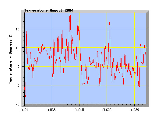
-3.9 |
14.5 |
3.6 |
0 |
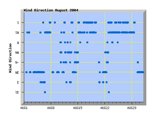
North East |
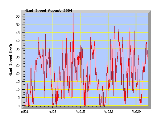
0.7 |
14 |
21 |
Frost. High cloud thickening during the day. Little wind. |
| 2 |
3.6 |
8.7 |
5.4 |
0 |
North East |
2.4 |
25 |
62 |
Low cloud and fog clearing by early afternoon but cloud returning in the evening. |
| 3 |
1.5 |
7.3 |
5.3 |
0.2 |
North East |
5.1 |
28 |
128 |
Cloudy with morning drizzle, cool NE wind. |
| 4 |
5.4 |
10.3 |
7.9 |
1.4 |
North East |
13.9 |
42 |
294 |
Cloud increasing during the day with showers at night. Cool gusty NE wind. |
| 5 |
8.2 |
11.1 |
9.5 |
1.0 |
North East |
9.9 |
39 |
245 |
Morning drizzle. Low cloud with cool NE winds, showers in the evening. |
| 6 |
7.6 |
10.2 |
9.2 |
73.8 |
South West |
11.3 |
44 |
279 |
Rain all day. Easterly winds turning southerly late morning. |
| 7 |
6.4 |
10.1 |
7.8 |
8.6 |
South West |
9.1 |
35 |
227 |
Cloudy with showers, southerly wind. |
| 8 |
1.0 |
12.1 |
6.2 |
3.4 |
North East |
1.7 |
21 |
45 |
Light frost. Cloud increasing mid afternoon with showers. Light winds. |
| 9 |
3.4 |
13.1 |
8.2 |
0 |
North East |
3.5 |
24 |
91 |
Some cloud at times, sunny with an afternoon NE wind. |
| 10 |
1.9 |
14.6 |
7.6 |
0 |
North West |
3.8 |
40 |
99 |
Some cloud but sunny with gusty NW winds for a time. |
| 11 |
3.9 |
12.4 |
8.1 |
1.0 |
North East |
8.9 |
44 |
223 |
Showers followed by a blustery southerly change mid-morning quickly clearing to a sunny afternoon. |
| 12 |
5.8 |
19.3 |
11.9 |
0 |
North West |
5.6 |
39 |
141 |
Some high cloud, mostly sunny with warm west to NW winds. |
| 13 |
6.6 |
13.9 |
9.2 |
0 |
North East |
11.3 |
57 |
277 |
Gusty nor'west wind at first turning cooler southerly mid morning but remaining dry. |
| 14 |
5.9 |
17.3 |
11.7 |
0 |
North |
9.8 |
37 |
242 |
Variable high cloud, warm northerly winds. |
| 15 |
0.1 |
14.2 |
4.7 |
17.0 |
South West |
8.7 |
36 |
215 |
Cloudy with morning rain. Temperature falling during the day and snow falling mid afternoon. Southerly winds. |
| 16 |
-0.1 |
5.6 |
1.8 |
11.8 |
South West |
2.8 |
27 |
73 |
Snow overnight. Cloud clearing and the snow melting, cold southerly breeze. Rainfall recorded is melting snow. |
| 17 |
-0.5 |
7.5 |
3.6 |
5.8 |
South |
9.5 |
46 |
237 |
Morning snow showers clearing but remaining cloudy. Southerly winds increasing with a few afternoon showers. |
| 18 |
4.8 |
7.1 |
5.8 |
0.6 |
South West |
13.9 |
40 |
342 |
Cloudy with drizzle at times and a cold southerly wind. |
| 19 |
1.9 |
9.1 |
5.7 |
3.8 |
South West |
3.8 |
20 |
98 |
Morning low cloud and drizzle. Cloud breaking in the afternoon. |
| 20 |
-0.4 |
8.7 |
4.3 |
0 |
North East |
0.9 |
13 |
26 |
Cloudy but dry with light NE breeze. |
| 21 |
4.2 |
11.3 |
6.9 |
0 |
North East |
4.4 |
27 |
113 |
Morning cloud clearing to a mostly sunny afternoon with a cool NE wind. |
| 22 |
4.0 |
16.8 |
8.8 |
0 |
North East |
7.5 |
41 |
188 |
High cloud clearing to a mostly sunny afternoon. Nor'west winds, gusty at times. |
| 23 |
0.8 |
7.4 |
3.8 |
2.2 |
South |
10.4 |
49 |
252 |
Overnight showers with snow on the Port Hills. Some cloud but mostly sunny with a cold southerly wind. |
| 24 |
0.9 |
6.2 |
3.6 |
0.8 |
South West |
14.8 |
47 |
362 |
Showers with hail and a few snow flurries. Cold southerly wind. |
| 25 |
1.7 |
7.4 |
4.1 |
5.2 |
South West |
9.2 |
42 |
228 |
Cloudy with showers, some with sleet and a cold southerly wind. |
| 26 |
-0.9 |
8.4 |
4.0 |
3.8 |
South West |
5.0 |
42 |
129 |
Morning frost, cloud increasing during the day with showers from late afternoon. |
| 27 |
1.9 |
5.9 |
4.0 |
11.6 |
South West |
10.1 |
48 |
250 |
Cold southerly winds with rain, sleet, hail and snow showers. Snow on the Port Hills. |
| 28 |
1.4 |
5.1 |
3.4 |
16.8 |
South West |
6.9 |
46 |
174 |
Cold southerly winds with rain and sleet showers. Snow on the Port Hills. |
| 29 |
-0.2 |
7.8 |
4.0 |
3.6 |
South West |
5.6 |
31 |
142 |
Showers and cloud clearing to a mostly sunny afternoon, cold southerly winds easing. |
| 30 |
-1.2 |
10.8 |
4.6 |
0 |
North East |
4.4 |
27 |
113 |
Frost. Sunny, some cloud in the evening, cool NE wind. |
| 31 |
5.3 |
10.7 |
4.6 |
0 |
North East |
13.1 |
39 |
320 |
Sunny morning with high cloud increasing. Cloudy afternoon with cool nor'east wind. |